The downstream of the Sittaung River in Myanmar consists of complex and dynamic system of shoals and braided channels. Morphology of the estuary changes actively owing to river flow and tidal motion including tidal bore. Severe riverbank and coastal erosion around the mouth of the Sittaung River has been a pressing issue in Myanmar. Since 2014 erosion at the west side has caused substantial loss of agriculture land.
Under the background, in May 2017, the government of Myanmar requested ICHARM to plan erosion control measures. After discussing how it should respond to this request, ICHARM conducted a joint field survey with the University of Tokyo, which has been involved in other research projects in Myanmar, to investigate and understand the current situation of erosion-related issues.
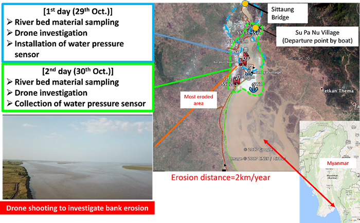 Figure 1 Location and activities of field survey on 29 and 30 October 2017
Before the field survey at the selected sites, the preliminary image analysis was applied to severe coastal change region using ALOS-2 and Landsat-8 satellite data between 2007 and 2017 processed by Dr. Kwak. For example, Figure 1 shows that the maximum lateral erosion distance on the right bank is over 2 km despite one year. During these two days survey, the team collected sediment materials from the riverbed and the bank for analysis of grain size distribution and sediment properties. The Arial photos and videos were also captured the representative eroded areas (H marks in Figure 1) using Drone (MAVIC pro, DJI) to investigate river bank erosions as well as to understand the current situation of the problem of riverbed and bank erosion. The team also measured river water level which seems to be affected by tidal level by installing water pressure senor at the River in Su Pa Nu Village for these two days. The water depth along the boat route during the field investigation were also measured using fish detector (fish sonar).
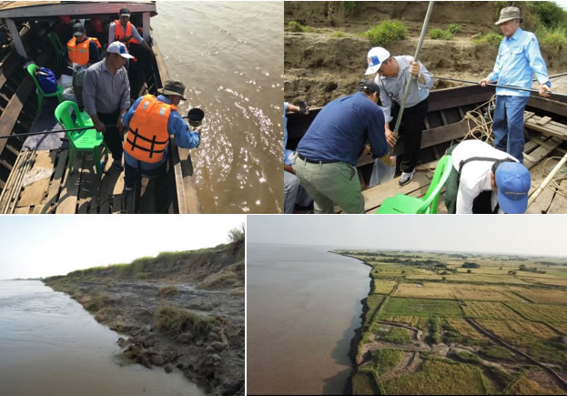 Collection of sediment material form the riverbed and bank
Based on the survey result on October 2017, an additional field survey was conducted by Research & Training Advisor Shinji Egashira, Senior researcher Atsuhiro Yorozuya, Senior researcher Badri Shrestha, Research Specialist Young-Joo Kwak, and Researcher Hiroshi Koseki. The following are the objectives;
The survey was cooperated by the Directorate of Water Resources and Improvement of River Systems (DWIR) of Ministry of Transportation and Communication (MOTC). During the survey, the participants were surprised to see dynamic phenomenon of bank erosions by the tidal bores, which were hardly seen in Japan. The results of this survey will be reported in the coming ICHARM Newsletter.
Bank erosion by tidal bores
Investigation by UAV (Unmanned aerial vehicle)
Investigation on sediment inflow condition by aDcp
Soil sampling collection