To predict the behavior of large-scale inundation in low-lying areas in a short period of time, ICHARM has developed a new numerical model called Rainfall-Runoff-Inundation (RRI) model. The model simulates various hydrologic processes including rainfall-runoff, stream-flow discharge, and inundation over floodplains in an integrated manner.
The RRI model is expected to help assess future flood risk for various regions with different climate conditions, for example, based on climate change projections. Similar to the IFAS system, the model is also applicable to large-scale flood prediction on a near real-time basis by using satellite-based topography, land-use and rainfall information.
The RRI model was awarded for its excellence in 2014 by the Japan Society of Civil Engineers. The ICHARM researcher who developed the model also received 2013 Young Scientists' Prize by the Ministry of Education, Culture, Sports, Science and Technology, and received the 15th Infrastructure Technology Development Award by the Ministry of Land, Infrastructure, Transport, and Tourism in 2013.
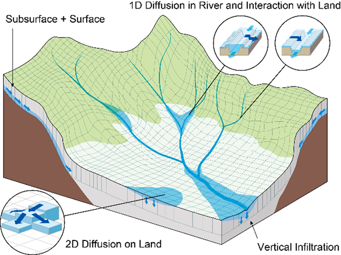 Schematic diagram of the RRI model
For more information, please visit here.
ICHARM has been developing a real-time flood forecasting model for small and medium-sized rivers. As one of the results of this project, we have developed an improved a graphical user interface for RRI (RRI-GUI) by incorporating more accurate domestic data and an extra function, and more user-friendliness. The following lists newly added data and function:
The RRI model with the new RRI-GUI can be downloaded the "RRI-GUI_1_4_2_7_GUI_Beta.zip" file from the BetaVersion folder on the RRI model download page.